



Roseville's Favorite Walking Running Biking Trails

Geoff Goolsby
I’m a trusted real estate advisor serving Roseville and the greater Sacramento area, helping thoughtful homeowners navigate buying and selling with ...
Best of Roseville Series · Updated for 2025
Roseville's Favorite Walking, Running & Biking Trails
An updated look at the routes Roseville's runners, riders, and walkers actually use — from an 8-mile creekside out-and-back to a quick sculpture-lined loop — and what that trail access means if you're buying or selling nearby.
This post has been one of our most-read for years, and for good reason — Roseville's trail network is a real reason people move here. We've gone back through it to update distances, routes, and trailhead access points with current information, and we've added something the original post didn't have: a look at how this trail network actually affects home values and neighborhood demand. If you're a regular runner, rider, or walker in Roseville, or you're searching for a home near one of these corridors, this one's for you.
Built for Movement: Roseville's Trail Network
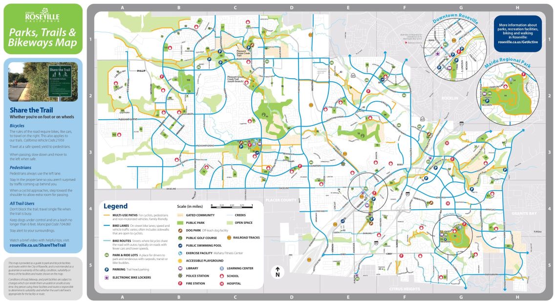
Roseville's paved trail system has quietly become one of the most extensive in the Sacramento region, connecting neighborhoods, parks, and creek corridors into routes long enough for serious training and short enough for an easy evening walk. Most of these trails are paved, low-traffic, and maintained by the City of Roseville's Public Works department — which means they're built to handle daily use from runners, cyclists, dog walkers, and commuters alike.
Sources: AllTrails.com; Komoot; City of Roseville Parks Department
A quick note on what's changed since this post first went up: the Maidu Park Loop is most accurately measured today at 3.4 miles, not the 2-mile figure originally cited — AllTrails and Komoot both list it consistently at that distance, with about 85 feet of elevation gain. And what was previously labeled "Dry Creek Trail" is now officially the Dry Creek Greenway Trail, with Phase 1 — a brand-new, fully paved ~2-mile corridor from Riverside Avenue to Rocky Ridge Drive — completed and open as of 2026. The full planned corridor is 4.25 miles, with Phases 2 and 3 still to come.
"These aren't forgotten paths behind a parking lot. They're maintained, connected, and used every single day."
Below are the five routes that made this post a reader favorite in the first place — updated with current distances, access points, and a fresh look at what each one means if you're buying or selling nearby.
The 5 Trails Readers Keep Coming Back To
These are the five routes from this post — Maidu Regional Park, Dry Creek Greenway Trail, Miners and False Ravine Trails, Pleasant Grove Creek Trail, and Sylvia Besana Park Trail — refreshed with current distances and access details. Each works well for walking, running, or biking, and each connects to a different part of the city.
Maidu Regional Park
Maidu Regional Park remains one of the best all-around destinations for a weekend walk, run, or ride in Roseville. The Maidu Park Loop — the trail that circles the park's interior and perimeter — is most accurately measured today at 3.4 miles with about 85 feet of elevation gain, a gentle correction from the 2-mile figure we originally cited. AllTrails and Komoot both rate it as an easy, family-friendly route that's popular with road bikers, runners, and walkers alike.
The park itself is 152 acres and includes the Maidu Community Center, Maidu Branch Library, Veterans Memorial Rose Garden, sports fields, a skate park, and the Maidu Museum & Historic Site. The museum's outdoor archaeological trail is a separate, shorter route — about half a mile of gravel path — that takes you past ancient petroglyphs and bedrock mortars left by the Nisenan Maidu people. Worth noting: this historic trail isn't ADA accessible and closes when temperatures exceed 99°F, so plan accordingly on hot days.
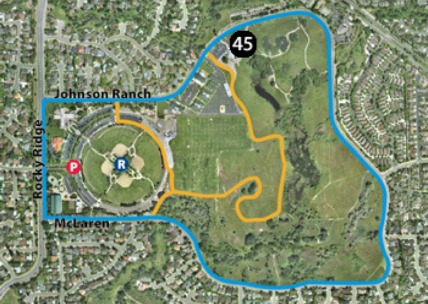
Map: Maidu Regional Park trail loop
Dry Creek Greenway Trail
The Dry Creek Greenway Trail — which runs alongside the Morgan Creek community and Morgan Greens neighborhood — has a new name and a significant update: Phase 1 is now officially open. The City of Roseville held a grand opening on May 9, 2026 at the new trailhead at 645 Riverside Avenue, marking the completion of the first segment of what will eventually become a 4.25-mile Class I paved multi-use trail along Dry, Cirby, and Linda Creeks. Phase 1 runs from Darling Way near Riverside Avenue east to Rocky Ridge Drive — a distance of nearly 2 miles — and replaces the generic "Dry Creek Trail" label you may have seen on older maps and guides, including our original version of this post.
The trail is a fully paved, off-street corridor designed for walking, running, biking, and dog-walking. It's also built with transportation in mind: according to the City of Roseville, the greenway is specifically intended to provide a safe, comfortable alternative to city streets for cyclists, connecting schools, businesses, and residential neighborhoods. Phase 1 construction was funded by approximately $30 million in State and Federal grants — no City General Fund money was used — which reflects how seriously this corridor was prioritized at the regional level.
What comes next is worth knowing. Phase 2, between Rocky Ridge Drive and Old Auburn Road, is currently in design with approximately $7.1 million in funding secured, and construction is estimated for 2027. Phase 3 timing depends on additional grant funding. When complete, the full corridor will stretch 4.25 miles and form part of a planned trail loop connecting the greater south Placer and Sacramento area.
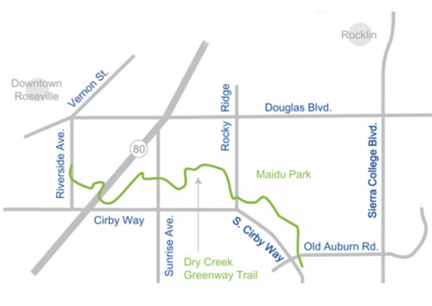
Map: Dry Creek Greenway Trail — Phase 1 now open (Riverside Ave to Rocky Ridge Dr) · Source: Original route overview; see City of Roseville for current Phase 1 alignment
Miners and False Ravine Trails
This combination remains one of Roseville's most popular routes for good reason — two trails, one trailhead, and a choice of direction depending on your mood. Starting from Sculpture Park (also known as Olympus Pointe Sculpture Park) behind The Home Depot on North Sunrise Avenue, you can head out on the Miners Ravine Trail toward Sierra College Boulevard, or take the False Ravine Trail in a different direction. Both routes run roughly 3 miles one-way through some of Roseville's most scenic open space and wetland areas.
Along the way, John G. Piches Park makes a natural stopping point — a good spot for a picnic or a quick game of basketball before heading back. The trailhead itself, Sculpture Park, is home to "Cosmos," a large sculpture by artist Aris Demetrios that's become a minor local landmark (from above, it's designed to resemble a rose bud opening into bloom).
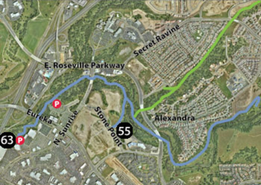
Map: Miners and False Ravine Trails
Pleasant Grove Creek Trail
The South Branch of the Pleasant Grove Creek Trail remains a favorite for West Roseville walkers, runners, and riders. Starting at Veterans Memorial Park, the one-way trip to Blue Oaks Park is about 1 mile, passing through beautiful open space and majestic oak trees along the way. The trail is mostly flat with some gentle inclines, and is paved for most of its length — comfortable for nearly any fitness level.
Baquera Park makes a good stop along the route, whether you're taking a breather or just want to extend your walk with a loop through the park itself. The combination of natural beauty, accessibility, and a manageable distance has kept this trail popular with fitness-minded residents in West Roseville for years.
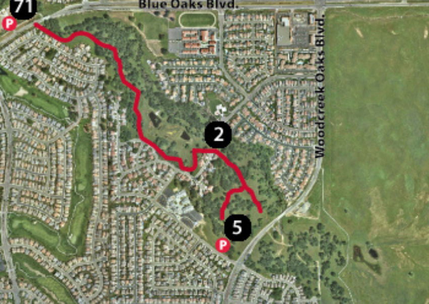
Map: Pleasant Grove Creek Trail (South Branch)
Sylvia Besana Park Trail
Sylvia Besana Park is a 4.5-acre neighborhood park in Central Roseville, dedicated in 2005 and named after Sylvia Besana — a Roseville native, educator, and community volunteer who spent much of her life giving back to this city. The park itself features a covered picnic area, baseball field, soccer field, swing and play areas, and a native plant area with mature redwoods, oaks, and maples providing generous shade. A concrete walking path connects all the areas of the park, with a connection to the multi-use bike trail beyond its borders.
What makes this trail worth knowing for walkers and runners specifically is its location. The trail runs alongside a creek and natural preserve, with the edge of Diamond Oaks Golf Course visible as you go. From here, the route extends naturally toward The Fountains shopping area and the Galleria — making it one of the more interesting urban-meets-nature runs in Roseville, where you're moving between open creek corridor and the energy of a walkable retail district within the same outing.
A quick practical note: there are no public restrooms at the park itself, so plan accordingly. The park sits adjacent to Catheryn Gates Elementary School, which means parking and foot traffic patterns vary during school hours.
Map: Sylvia Besana Park Trail (marker 5) · Trail runs along Trehowell Dr, adjacent to Diamond Oaks Golf Course
Trail Comparison at a Glance
| Trail | Distance | Surface | Best For | Nearby Area |
|---|---|---|---|---|
| Maidu Regional Park | 3.4 mi (loop) | Paved | Family walks, runs, rides | East Roseville, Rocky Ridge area |
| Dry Creek Greenway Trail Phase 1 Now Open | ~2 mi (Phase 1 open) | Fully Paved | Walk, run, bike, commute | Riverside Ave to Rocky Ridge Dr |
| Miners & False Ravine Trails | ~3 mi one-way (each) | Paved | Scenic mid-distance routes | Sculpture Park / N Sunrise Ave |
| Pleasant Grove Creek Trail | ~1 mi one-way | Paved | Easy daily walk or run | Veterans Memorial Park, Blue Oaks |
| Sylvia Besana Park Trail | ~0.25 mi (park) + extends to Fountains | Paved | Urban-meets-nature run | Highland Reserve, Central Roseville |
Sources: AllTrails.com, Komoot, City of Roseville Parks Department. Distances vary slightly by measurement source and exact start/end points. Individual trail conditions may vary by season.
The Real Estate Angle: What Active Buyers Actually Look For
When this post originally went up, it was framed purely as a recreation guide — and that's still useful. But over the years, we've noticed a pattern in conversations with buyers: people who run, ride, or walk regularly aren't just asking "is there a trail nearby?" They're asking more specific questions, and those questions map directly onto the trails above.
What Buyers Should Know
Distance and surface matter as much as proximity. The Dry Creek Greenway Trail's Phase 1 is a newly completed, fully paved 2-mile corridor — a very different daily experience from a shorter neighborhood loop. And because Phases 2 and 3 are planned and funded, buyers near the current Phase 1 alignment are purchasing proximity to a corridor that's actively growing. If you're a regular runner or cyclist, ask what the nearest trail actually connects to and how far it goes — not just whether a trail exists nearby.
What Sellers Should Know
If your home is within walking or biking distance of Maidu Regional Park, the Dry Creek Greenway Trail, the Miners/False Ravine network, or Pleasant Grove Creek Trail, name it specifically in your listing. "Near the Dry Creek Greenway Trail — Phase 1 now open" tells an active buyer something timely and specific. These are names that show up in searches from people who already know and love these routes, and the greenway's recent grand opening makes it a fresher conversation than ever.
"The Dry Creek Greenway Trail just opened its first phase after years of planning and $30M in investment. That's not a rumor about a future amenity — it's a finished trail you can walk today."
Who Benefits — and Who Should Ask Harder Questions
Roseville's trail network is a strong asset for the active community, but as with any lifestyle amenity, it's worth being clear-eyed about who benefits most and what's worth double-checking before making a decision based on trail access alone.
✅ Upside — Families & Casual Users
Maidu Regional Park and the Pleasant Grove Creek Trail's South Branch offer short, flat, paved routes that are comfortable for nearly any fitness level — ideal for a daily walk, a family bike ride, or an easy run close to home.
✅ Upside — Distance-Focused Athletes
Dry Creek Trail and the Miners/False Ravine combination offer enough mileage for serious training — roughly 7 miles and 3 miles one-way respectively — without needing to drive to a starting point.
⚠️ Consider — Surface Varies by Trail
Dry Creek Trail includes both paved and dirt sections. If a fully paved surface matters to you (for road biking or a stroller, for example), confirm which segment you'll actually be using before assuming the whole corridor is paved.
⚠️ Consider — The Maidu Museum Trail Is Separate
The Maidu Park Loop (3.4 mi) and the Maidu Museum's historic petroglyph trail (about 0.5 mi, gravel, not ADA accessible, closes above 99°F) are two different routes in the same park. Don't confuse the two when planning a visit.
What Active Buyers and Homeowners Should Do Right Now
If you're house-hunting and trail access matters to you
Don't stop at "is there a trail nearby?" Ask which trail, how long it is, and what surface it's on. A home near Maidu Regional Park offers a different daily experience than one near the Pleasant Grove Creek Trail's short South Branch, which is different again from one near the longer Dry Creek Trail corridor. Pull up the route on AllTrails before you tour — it takes five minutes and tells you more than most listing descriptions will.
If you're training for something specific
Match your typical workout distance to what's actually nearby. If you regularly run or ride 5+ miles, proximity to Dry Creek Trail or the Miners/False Ravine network gives you that distance without repeating short loops. If your routine is closer to 1–3 miles, Maidu Regional Park or the Pleasant Grove Creek Trail may be more than sufficient — and could open up more neighborhood options.
Visiting the Maidu Museum trail? Plan around the heat
If you're planning to walk the Maidu Museum's historic petroglyph trail specifically (not the 3.4-mile Maidu Park Loop), know that it's a separate, shorter gravel path that closes when temperatures exceed 99°F and isn't ADA accessible. Bring water, sunscreen, and a hat, and check conditions before visiting on a hot day.
If you're selling near a trail corridor
Be specific. "Near walking trails" is vague and doesn't tell an active buyer anything useful. "Two blocks from Maidu Regional Park" or "minutes from the Dry Creek Trail" tells a runner, rider, or walker exactly what they're getting — and these are the kinds of details that resonate with the buyers most likely to prioritize them.
A word on access points
Several of these trails have specific, well-known access points — Sculpture Park behind The Home Depot on North Sunrise Avenue for the Miners and False Ravine Trails, or Veterans Memorial Park for the Pleasant Grove Creek Trail's South Branch. If you're evaluating a home based on trail proximity, confirm which access point you'd actually use day-to-day, and whether it has the parking or amenities you'd want.
The Bottom Line
This post has earned its place as one of our most-visited pages because the underlying premise was always right: Roseville's trail network is a genuine asset, not a marketing footnote. What's changed is our understanding of how to talk about it — and in the case of the Maidu Park Loop, a small but meaningful correction to the actual distance (3.4 miles, not 2).
For active buyers, the takeaway is straightforward: these five trails — Maidu Regional Park, Dry Creek Greenway Trail, the Miners and False Ravine Trails, Pleasant Grove Creek Trail, and Sylvia Besana Park Trail — represent five genuinely different experiences, from a short neighborhood loop to a multi-mile training route. Knowing which one is closest to a home you're considering tells you something real about how you'll actually live there.
For sellers, specificity wins. Naming the actual trail and what it offers gives active buyers exactly the information they're already searching for. "Near trails" is forgettable. "Walking distance to Maidu Regional Park" or "minutes from the Dry Creek Trail" is the kind of detail that gets remembered.
These trails have remained favorites for years, and that's unlikely to change. As Roseville continues to grow, the city's ongoing investment in trail maintenance and connectivity means this network — and its effect on the neighborhoods it touches — is only likely to become more valuable over time.
This blog post is intended for informational purposes only and does not constitute real estate, legal, or financial advice. Trail distances, surfaces, and access information sourced from AllTrails.com, TrailLink.com, Komoot, and the City of Roseville Public Works department, and are subject to change — always verify current trail conditions and closures before heading out. Home value and market observations are general in nature; individual property values vary based on condition, location, and market conditions at the time of sale. Consult a licensed real estate professional for advice specific to your situation.
Free Strategy Session
Let's Talk About Your Next Move in Roseville
Whether you're buying, selling, or just starting to think about it — a strategy session with Geoff is the fastest way to get clarity. No pressure, no pitch. Just an honest conversation about your goals, the Roseville market, and what your best next step actually looks like.
— Geoff Goolsby · The Goolsby Group · Roseville, CA
Let's Keep in Touch
Subscribe to get updated on the most recent information from The Goolsby Group at Real Broker
We respect your inbox. We only send interesting and relevant emails.